Manaslu Circuit Trek Distance

The Manaslu Circuit Trek distance is approximately 170-180 km, forming a round trip around Mount Manaslu (8,163 m) which is the world’s eighth tallest peak. The Manaslu Circuit Trek distance that you hike every day is a decisive factor for the planning of your stamina, choosing the right gear, and having realistic expectations.
The Manaslu Circuit Trek is a full experience through the blooming and aromatic rhododendron forests, rice cultivated fields, and typical villages before reaching the rugged and rocky high-altitude areas. The typical duration of the trek is 14-16 days. However, this might change according to the needs of the hikers to get accustomed to the altitude, the weather, and their personal speed. The most challenging point is Larkya La Pass at 5,106 m which rewards with wonderful views of mountains covered with snow and valleys of ice. The trek is graded as moderate to strenuous. With careful planning, proper pacing and daily distance management, it is easily attainable.
The daily hiking distances vary quite a lot, starting from the short acclimatization walks from Sama Gaon to the long and challenging hikes over the high passes. If you don’t have the proper distance knowledge, the journey which should have been full of excitement, may turn out to be a very tiring one.
Our guide provides a day-by-day breakdown of the Manaslu Circuit Trek with the distance, the terrain and the landmarks for each day. From Samdo to Dharamsala distance, where slow and careful acclimatization is necessary before conquering the Larkya La, to the practical maps and the actionable tips that will aid you in trekking fast, efficiently and safely, we will cover everything. Knowing the daily distances and what each day offers will prepare you for a fun-filled experience of a full-fledged Himalayan adventure.
Daily Breakdown: Manaslu Circuit Trek Distance That You Hike Every Day
Day 1: Kathmandu – Machhakhola (930 m)
Distance: 160 km (7-9 hours by drive).
Day 2: Machhakhola – Jagat (1,340 m)
Distance: 22 km | Trekking duration: 7-8 hours.
Day 3: Jagat – Deng (1,860 m)
Distance: 19 km | Trekking duration: 7 hours.
Day 4: Deng – Namrung (2,630 m)
Distance: 17 km | Trekking duration: 6-7 hours.
Day 5: Namrung – Lho (3,180 m)
Distance: 10 km | Trekking duration: 5-6 hours.
.
Day 6: Lho – Samagaon (3,530 m)
Distance: 16 km | Trekking duration: 6 hours.
Day 7: Rest/Acclimatization in Samagaon
Distance: 3-5 km (short hikes) | Trekking duration: Variable.
Day 8: Samagaon – Samdo (3,875 m)
Distance: 8 km | Trekking duration: 5 hours.
Day 9: Samdo – Larkya Phedi (Dharamsala – 4,460 m)
Distance: 6 km | Trekking duration: 3-4 hours
Day 10: Larkya La Pass (5,106 m) – Bimthang (3,890 m)
Distance: 20 km | Trekking duration: 8 hours
Day 11: Bimthang – Gho (2,560 m)
Distance: 12-15 km | Trekking duration: 5 hours
Day 12: Gho – Dharapani (1,860 m)
Distance: 7-10 km | Trekking duration: 4-5 hours
Day 13: Dharapani – Kathmandu (1,400 m)
Distance: 220-240 km | Duration: 7-9 hrs (by road).

Mini Story: Why Distance Alone Can Be Misleading
A group of trekkers once set out from Samdo to Dharamsala, thinking that they could easily do the day walk. A distance of only 6 km looked like one of the lightest days of the Manaslu Circuit Trek. No hurry, no pressure, just a gentle uphill before the big pass day.
But on the trail, things were different. Over 4,400 meters, every step demanded extra effort. Breathing became heavier, the frigid air made them slow, and they had to stop often, although the distance was short. What they thought would take only a couple of hours turned out to be far more strenuous than the longer days at lower elevations.
When they finally arrived at Dharamsala, the group learned an important thing that distance alone cannot tell the difficulty of high-altitude treks. The elevation gain, the altitude, the weather, and the roughness of the ground could turn even a short hike into a physically and mentally challenging day.
Thus this experience proves that hiking day by day with a Manaslu trek map, realistic timing, and proper acclimatization is most important. It seems logical for trekkers to keep themselves informed about both the altitude and the distance they should cover. This is to be able to manage their energy levels more efficiently and enjoy safer hikes.
Actionable Tips for Daily Trek Distances
Acclimatize Gradually
It is advised not to push your limits on long trekking days. High altitude hiking should be done by incorporating short segments together with rest days so that your body can get used to the high altitude. Besides, you should pay attention for the signs of altitude sickness like headaches, nausea, or dizziness, and slow down if necessary.
Carry Water and Snacks
Trekking at a high altitude is an energy-consuming activity. Therefore, it is very important to keep yourself hydrated and properly fed. Pack snacks that are lightweight and high in calories like nuts, chocolate and energy bars. Rather than consuming a lot of water at once when you feel thirsty, try drinking small amounts regularly.
Monitor Weather Closely
Mountains have very unpredictable and rapidly changing weather situations. Rain, snow, or strong winds can be the reasons why you will have to stop your trip. Checking the weather forecast the day prior will help you to know if you should slow down your pace or find a place to stay. Carrying a waterproof jacket, extra layers, and gloves will be your protection against sudden cold or wet conditions.
Track Distance Daily
You can keep a record of daily distances covered by using a GPS watch, trekking app or even your phone. Being aware of your progress would help in planning breaks, water stops and overnight stays. Tracking also enables you to manage your energy and avoid overexertion on consecutive long days.
Pace Yourself Wisely
The best way to avoid getting too tired is to break up the long hours into several small parts and set small goals for each day. Similarly, it is advisable to keep a constant and sustainable pace rather than to accelerate right from the start.
Rest and Recover
Intervals of short breaks every hour improve stamina and concentration. You can ease muscle tension by stretching after each break especially on downhill sections.
Know Your Body
Tiredness, hunger or altitude symptoms should always be in your consciousness. Don’t hesitate to take a break or to slow down.
Use Trekking Poles
Using trekking poles decreases the load on the knees when going downhill. It helps you gain balance on rocky or uneven trails.
Plan for the Longest Days
Find out which days of the hike have the greatest distance or climbing and prepare for them accordingly.
Manaslu Circuit Trek Map With Distance
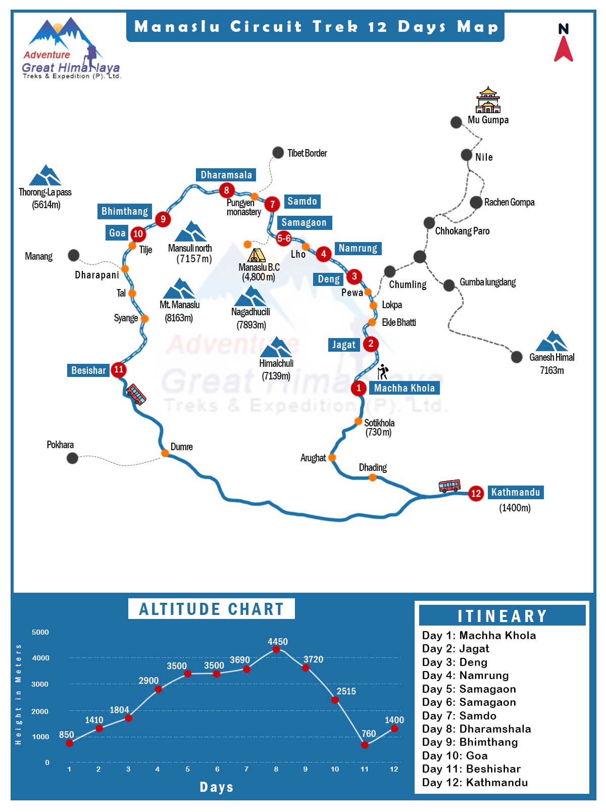
A detailed Manaslu Circuit Trek map with distance is one of the prime tools for a safe and enjoyable trek in this remote Himalayan region.
Unlike simple route maps, a detailed distance-based map shows the daily trekking distances, the ups and downs of the terrain, the spots for acclimatization and the points of interest along the way in one single diagram. It gives you a vision of your daily walking like where the ground will be tough and how the elevation changes.
A map with distances offers you a mental picture of the daily trail sections. It will be easier for you to determine when to take rest breaks, where to stop for water and where to stay overnight.
Referencing a Manaslu Circuit Trek map with distance, the likelihood of overexertion is significantly reduced. The whole process of acclimatization can become much easier, your confidence increases and you will have mental peace.
A Manaslu trek map is strongly advised before you set off. Visualizing daily distances, elevation changes and trail segments helps prevent overexertion and manage energy levels. Besides, having a map lets you know key locations, acclimatization spots and resting places. This makes the journey smoother and more enjoyable.
Ready to Take on the Manaslu Circuit Trek?
The Manaslu Circuit Trekking is a new experience every single day with the serene valleys, ancient villages and the soaring, craggy mountains. From the lush green river valleys at the start of the trek to the treeless, desolate landscapes at the Larkya La Pass, each day is rewarding in its own way.
Knowing the daily distances of the Manaslu Circuit Trek is a major factor for the physical and mental preparedness of the trekkers on this adventure. Daily distances vary widely. Factors like elevation, type of ground, and condition of the weather often play important roles in determining how hard or easy a day feels. The short stretch from Samdo to Dharamsala can be surprisingly hard because of the limited oxygen. Likewise, the longer day of the Larkya La Pass crossing requires endurance, patience and an early start.
If you prepare for your trek with the realistic daily kilometers and hiking hours you can conserve your energy better, be less fatigued and enjoy the trip rather than struggling for it. Proper planning saves energy, promotes acclimatization, and lets you immerse yourself in the beautiful mountain scenery, quiet villages, and alpine terrains along the way.
Ready to plan your Manaslu adventure? Get yourself a detailed Manaslu Circuit Trek map, take a look at the daily distances beforehand and select our itinerary that follows smart pacing. If you prepare well, you can walk on to the route with full confidence and conquer one of the most rewarding trekking routes in Nepal.
Speak to our local travel expert, who can assist you in planning your trip.
PLAN YOUR TRIP OR
Chat via WhatsApp
 Tuesday, January 27th, 2026
Langtang Valley Trek In Jun
 Tuesday, January 20th, 2026
Best Treks In Nepal In February
 Sunday, January 18th, 2026
Langtang Trek In July
 Wednesday, December 31st, 2025
Manaslu Circuit Trek Distance
 Thursday, November 27th, 2025
Mardi Himal Trek Guide- Itinerary & Price
 Wednesday, November 26th, 2025
How Hard is the Mardi Himal Trek?
 Friday, November 21st, 2025
Travel Insurance For Everest Base Camp Trek
Wednesday, December 31st, 2025
Manaslu Circuit Trek Distance
Tuesday, January 20th, 2026
Best Treks In Nepal In February
Tuesday, January 27th, 2026
Langtang Valley Trek In Jun
Sunday, January 18th, 2026
Langtang Trek In July
Friday, November 21st, 2025
Travel Insurance For Everest Base Camp Trek
Thursday, November 27th, 2025
Mardi Himal Trek Guide- Itinerary & Price
Wednesday, November 26th, 2025